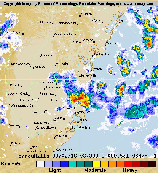
This ABC report on an AFL match at Drummoyne Fri evening 9 Feb mentions it was interrupted by a “huge” storm with heavy rain.
Odd that a storm such as reported slips through the Sydney rain gauge network.

If anybody has other rain data or observations please pass on.
Imagine what rain must be missed out in the wide brown land.
Here is the Terrey Hills radar ex Oscilmet I chose the loop from 3pm to 8pm 9Feb18 – the times on the loop are in UTC – the little rain centres move rapidly. The one that hit Drummoyne is fairly clear. I think they only archive for 2 weeks.
Here is a radar image for ~7.30pm that evening from the Oscilmet archive.

The little storm centers were passing from WSW to ENE.
I see at AWN Sydney Olympic Park got 9mm
Wazz,
9mm of rain is a lot of rain – if you live in Timbuktu.
The Broome gauge knows what ‘a lot of rain’ means. Just 370 mm last 23 hours beats the 1932 record by 68 mm. Quite a hammering. I guess stores will have to come by barge again!
West Roebuck, 30km to the east had the same rainfall.
That’s about 1.5m for 6 weeks.
Drummoyne is 8 or 9 kms west of Observatory Hill. It’s not uncommon in the Sydney Basin for one or two suburbs to cop a belting and the next suburb gets drizzle or nothing.
I get around the city/metro area heaps and often remark how much it rained in the city or some suburb and how little there was elsewhere.
For the 9th Feb the BoM predicted, “The chance of a thunderstorm in the outer west in the afternoon.” (As reported in The Australian’s Weather Page. Drummoyne is inner west.
The Australian, weather page (BoM), 9th Feb, predicted, “The chance of a thunderstorm in the outer west in the afternoon.”
Drummoyne is inner west, is about 7km from Observatory Hill.
We often get localised storms in the Sydney Basin. One or two suburbs cop it and the rest get drizzle or nothing.
I have added 5hrs of the Terrey Hills radar loop to the blog. Here is the Terrey Hills radar ex Oscilmet I chose from 3pm to 8pm 9Feb18 – the times on the loop are in UTC – the little rain centres move rapidly. The one that hit Drummoyne is fairly clear.
If the tally of rainfall, anywhere, begins to challenge the tenets of “Global Warming’ Theory, the BOM has a special lid that they rush out for the rain-gauge.
Tom – I have just checked the stunning Broome rain data for this year – so far within 30mm of the all time highest annual rain total it February has not ended.
Broome PO 3002 has data from 1890 to 1952 and 1896 saw the record ann max rain of 1,094mm.
Broome Airport 3003 has data from 1939 and the ann max was 1,496 in 2000 making the all time record.
In 2018 Broome Airport has seen 915.6mm in Jan and so far in Feb 551 which makes 1,466.6 – so 29.4mm to equal the all time annual rain record. I can not recall seeing a rain record smashed like this.