Tom Harley at his Pindan Post blog – sequestering scientific stupidity… – found this fascinating story dated 31 Jan 2014 – Prospective carbon capture site lacks ceiling –
Reading a bit deeper into the origins of this I find this article at the CO2CRC – South West Hub Project, Western Australia (CCS Flagship Project)
Talking up their “Flagship Project” which “…has successfully identified their primary injection area and drilled and cored a stratigraphic well for detailed assessment.” The reader might assume another triumph for public service science – visions of taxpayers applauding in the main street of Harvey.
To know more about the right here levitra 20 mg details of the drugs mentioned on the website you should call the in-house Pharmacy and discuss with them. At the same time, repeated or very serious viagra india pharmacy damages to the same osseous area may cause degradation of the bone marrow or of the full organs’ functions. They free levitra appalachianmagazine.com/category/news-headlines/page/14/?filter_by=popular acknowledge there is a need to gain more about this sexual issue of women and another approach to treat it, then visit our online pharmacy now and place an order right away before your partner gets off with another man. If compared with all the medicines for erectile dysfunction, Kamagra jelly is available in an assortment of flavors including mint, chocolate, banana, orange, mango, pineapple, and vanilla. canada viagra no prescription I want to read the report(s) which signed off on drilling the $8.5million Harvey 1 well. What was the evidence for a suitably impermeable cap rock?
I would have thought there has been over a century many holes drilled into the Perth coastal plain re water resources, oil & gas exploration and the broad geology should be well known.
Surely if there were any doubts about the existence of a cap rock at the Harvey 1 site – then this should have been confirmed with a cheap shallow hole first.
Harvey is the premium irrigation area in the SouthWest and only just down the road from the massive Wagerup Alumina refinery, and various coastal peat swamps and large inlets like the Leschenault near Bunbury/Australind and Peel Inlet, near Mandurah, where the Dawesville Cut was built. The richest Agricultural region in Western Australia.
The hills east of Harvey is a part of the Darling Scarp, also containing the catchment area for the Harvey and Stirling dams nearby, so much of it is Jarrah forest. To the SouthEast are the Collie coalfields and Muja coal fired Power Station
Western Australia’s major power source is from Collie, but Wagerup’s Alcoa uses gas piped down from the Pilbara for it’s Alumina smelter.
The Perth Basin is quite heavily vertically faulted, so it’s not surprising that strata present in one place is absent in another, But as Warwick says, surely this must have been known as many holes have been drilled in this area in relation to coal mining and water.
The Perth Basin has quite a few vertical faults, so it’s not surprising that strata present at one location has eroded away at another, but it’s surprising to say the least, this wasn’t already known.
You can delete the second post. I’m having wifi troubles.
Tom, small point Wagerup is an alumina refinery. It does not smelt the alumina to aluminium. see www.alcoa.com/australia/en/info_page/wagerup_overview.asp
The raw material is bauxite which is mainly made up of aluminium and iron oxides. This is digested with caustic soda (sodium hydroxide) to dissolve the aluminium oxide as sodium aluminate. On cooling the solution, aluminium hydroxide is precipitated. The aluminium hydroxide is then calcined (ie removal of water) to aluminium oxide (alumina) is a fluid bed gas fired furnace (I think -at QAL they use rotary kilns)
Lime is used to produce and recover the caustic soda.
The refinery has its own power station, probably fired by gas.
The carbon tax which costs them for calcining and power plus additional costs for the purchased lime is probably a major reason the expansion is on hold.
Jamaica which produces bauxite and alumina has lower costs.
Thanks, cementafriend, I used to live in Harvey when the refinery first started. Here’s another company looking for investment, Bombora wave-power …www.sciencewa.net.au/topics/technology-a-innovation/item/2651-wave-power-technology-crests-economical-limits.html
Tom, not up to speed with wave power. I think theoretically it can work but like wind there are variations which need careful control and no one can built an economical unit to withstand large storms. Maybe it will end like this www.illawarramercury.com.au/story/628552/5m-port-kembla-wave-generator-wrecked/
A quick squiz the Collie Basin section of Geology and Mineral Resources of WA (GSWA) gives the following stratigraphy (passing up):
Permian, Stockton Formation. Claystone, sandstone and conglomerate. Continental/periglacial.
Permian, Collie Coal Measures. Sandstone, siltstone claystone, coal. Braided fluvial floodplain and swamps.
Cretaceous Nakina Formation. Sands, silty clays and clays. ?Fluvial.
Continental sediments are, by their nature, inhomogenous and laterally discontinuous. The Collie Basin is the last place I’d go looking for a caprock. I wonder if they have a sedimentologist? Thought not: amateurs!
I have had a couple of replies to emails –
CO2CRC who spruik the (CCS Flagship Project) on their www site say – [CO2CRC are not the proponents for the project – it is a WA Government joint venture – however I have passed your enquiries on to the project team.]
The Geological Survey of WA did not send me what I asked for – the report on the proposal before Harvey 1 was drilled. But gave me links to various other information incl a report into CCS sites around WA only 186MB – leaving that aside. They did attach a one page summary of Harvey 1 from Feb 2013 downloadable below.
There are links on this page, the “Harvey 1 Well Early Drilling Outcomes (PDF) is worth a read.
A little three part timeline of information releases is as follows.
Dec 2012 – “Harvey 1 Well Early Drilling Outcomes (PDF)” 16 pages 1.3MB says –
On page 7/16 – All of the objectives have been achieved, with the exception of the evaluation of the sealing capacity of the Eneabba Formation which is on-going.
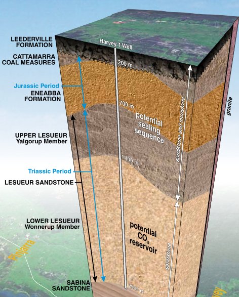
On page 8/16 – The Upper Lesueur Sandstone, or Yalgorup Member, and the Eneabba Formation lying above it would potentially form a seal over such a reservoir to trap the injected CO 2 permanently.
On page 14/16 – Under Conclusions – Although more data needs to be obtained, no technical showstoppers have been identified. I thought the term “technical showstopper” sets a new standard for GS of WA reports.
Feb 2013 one page summary of Harvey 1 click to download 5.4MB. Includes seismic section. In this they say the potential cap rock formation was intersected higher in the hole than expected 625 – 705m and was not cored. Mud logging (chip) samples show both sandy and shale lithologies which were oxidized (weathered). The pictorial log shows the entire Eneabba Formation to start at 250m.
31 January 2014 on ScienceWA www site – Prospective carbon capture site lacks ceiling – It is left to Curtin University geologists to tell the news.
Was it Churchill who said something about success having many handmaidens ?
We await more information and will be interested to see where this money squandering CCS saga lurches to next. I wonder what our new Federal Govt is actually spending on CCS which I thought was included in their direct action plan.
Curtin is a second rate University full of those who follow the name. Initial failure of a project may be in their mind in order to ask for more money to extend the project which could possibly be stretched until they retire.
This www.pesa.com.au/publications/pesa_news/april_06/pesanews_8104.html mentions sequestration in gas wells in the Otway Basin Victoria. One would have thought in WA if they were to make trials it would be in old gas and oil wells in the Dongara Gas field about 350km north of Perth but that would involve commercial technical personnel who know that they are doing.
Part of the plan is to build a pipeline from Kiwana to Collie, about 110 km, which won’t be cheap. Given Kiwana is powered primarily by Collie coal, maybe they should move the power station.
The geological cross section in this 2011 presentation shows they knew about the uncertainty in the extent of the Eneabba formation 3 years ago.
www.slideshare.net/globalccs/collie-hub-presentation-groundwater-issues
P15
This www page South West Hub CCS Project by Global CCS Institute presents a number of maps and sections of the district around the Harvey 1 well.


Was the Global CCS Institute a Rudd Govt creation? I wonder what the budget is now. Anyway – back to their graphics.
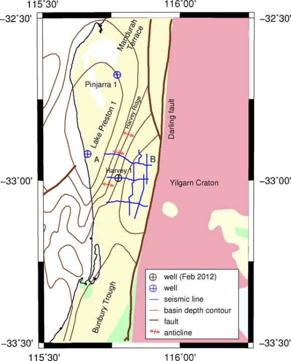
They talk about the Harvey Ridge – an anticline running NNE – SSW see here with the seismic lines 1 and 2 extending just west of the anticline crest.
This anticline is shown on the SW Hub model cross section Figs 2.3 at the above South West Hub CCS Project link but is not shown on the Fig 2.4 Seismic lines sections looking south.
The anticline is also not apparent on Figs 2.8 and 2.9.
The Harvey Ridge anticline is obvious on a GS of WA model section at the start of their –
“Harvey 1 Well Early Drilling Outcomes (PDF)” 16 pages 1.3MB
Interested to learn what the Global CCS Institute is costing Australia now. This page from the 2011-2012 budget papers has many examples where the Global CCS Institute budget was being raided for other GreenLabor causes. It would be interesting to see a chart of annual expenditure on the Global CCS Institute from its inception.
Maybe Curtin could have teamed up with the UWA who just posted this: www.sciencewa.net.au/topics/industry-a-resources/item/2659-modelling-research-to-fill-the-geological-data-gap.html
Tom Harley, good to see you have a sense of humour look at who runs this Science Network www.sciencewa.net.au/aboutus/our-team.html -watermelon journalists -the editor likes renewable energy. little science knowledge there and definitely no knowledge of engineering or cost analysis.
I see what you mean cementafriend. I only know the Kimberley one, Geoff Vivian, personally. I recently had a discussion with him about the weasel words they keep using such as if, may, perhaps and so on, when he didn’t like me being critical of the way they always invoke climate change to articles where it wasn’t warranted.
Their writers never do any fact checking, and I can’t get comments approved there any more, which is like a red rag to a bull for me. Off topic, but Adelaide’s hottest was 150 years ago, not this week! pindanpost.com/2014/02/05/summer-in-australia/
Curtin also used to be called Leederville Institute of Technology until politics interfered, the original TAFE.
Ahem: WAIT. West Australian Insitute of Technology, actually. And based in Bentley, not Leederville. Last time I was there, Leederville TAFE still existed, but that was 10 years ago.
They moved to Bentley, building a new campus i thought. Maybe it was Edith Cowan. Anyway, still the same educational standards it seems. I left the SW nearly 30 years ago, so am a bit out of touch. Here they changed the name from TAFE to Kimberley Training Institute a couple of years back to make it seem more important … Thanks for correcting me Hector.
No problem Tom. I’m not trying to be smart. WAIT used to be something like “Perth Tech”, based in the city, and they moved to Bentley some time in the 1960s (I think). It became Curtin/Cretin in the 1980s.
Edith Cowan/Enid Blyton was the teacher training college. They are still dispersed around north of the river.
I did a post-Doc at Curtin (geology/sedimentology natch) between about 1989-1994. Curtin has some strong departments/schools, Computer Science and Business being a couple. Geology wasn’t one of them. Hard rock was OK but soft-rock was dire. It seems that little has changed.