10 thoughts on “Sydney fires 17 October 2013 – why the hell not this no brainer ?”
Great photo! Over California or Colorado? With the propensity for bush-fire in Australia one would think that a few of the by now ageing old work-horses – 747’s could be purchased for this purpose, especially now with the new Dreaminers and Airbuses coming into general service.
A pet issue of mine. If you build on a floodplain you pay an appropriate insurance premium for flood damage, but bushfire damage is covered by a general home insurance policy. In effect the rest of us pay twice over (in insurance premiums and taxes for fire fighting resources) for a lifestyle choice of a generally affluent group of people to live in or close to the bush.
Worse, the subsidy encourages people to not take appropriate preventive actions, such as cutting bush, and encourages more to live in the bush. Not too long ago, I was in a forested area south of Perth and there was house after house every 30 meters or so, all within a couple of meters of bush and trees. Every single one of them would go in a bushfire.
I understand the reason for the difference. You can determine flood risk by looking at a map, but bushfire risk can only be assessed on the ground and at least once a year.
The solution is to exclude bushfire coverage from home insurance, but that is a political non-starter.
Here is the Evergreen site Faq on their 747 tanker.
The reports on the Sydney bushfires are utterly devoid of information as to what extent the affected areas had been protected by cool weather fuel reduction burns. What fuel reduction targets were set? What was achieved – this year? Last year? In the last five years?
We can’t control the weather or possibly hope to prevent ignition. We can only control the level of fuel. Firestorms are a lethal form of fuel reduction NSW and Victoria must cease relying on.
There is a statewide archive of scheduled hazard reduction burns here –
many refer to villages & towns –
I saw one ref to Bilpin –
28/09/2013 to 30/09/2013 Hawkesbury Between 2445-2455 Bells Line of Road, Bilpin Private NSW National Parks & Wildlife Service, Rural Fire Service
there may be others relevant.
I saw two refs to Blue Mnts –
21/09/2013 to 21/09/2013 Blue Mountains Mount Hay Road, Leura Private Private, Rural Fire Service
and –
27/09/2013 to 27/09/2013 Blue Mountains Between Cliff & Glenraphael Drive, Katoomba Local Government Authority Local Government Authority, Rural Fire Service
But I only looked back to 19 Sept.
It would be fascinating to know what was actually done and if a statewide map of areas burnt in hazard reduction is collated. My guess is they will be pinpricks compared to areas burnt by wildfire.
Interesting example of how the media believes its own distortion of reality about bushfires.
AMERICA, the nation which gave the world 307 Nobel laureates, has today shown that its media is about as smart as one of its famously dopey teen beauty pageant contestants.
In a bizarre map produced by NBC News, pretty much the whole of Australia is depicted as being ablaze this week.
You might have thought the bushfires of the past week have been confined largely to New South Wales, but noooo. Not according to NBC they’re not.
According to NBC, pretty much the entire country is on fire, including vast swathes of Cape York, the entire Darwin region, and vast portions of Western Australia’s Great Sandy Desert where you’d be lucky to find two blades of grass to rub together.
The image is derived from the Landsat satellite and is accurate. The fires are real, but they are in unpopulated areas and nothing is done about them. The issue in the East, isn’t the bushfires per se, but the fact people live in the bush. If nobody lived in the bush, which is the case of most of WA, the fires could be allowed to burn.
Can carry 75,700 litres which depending on the density of the retardant could be anything from 150 to 75 tons.
The retardant is dumped under pressure so this spreads it evenly and help make the retardant more effective.
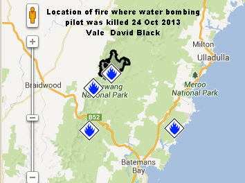
Some interesting comments on this aviation specialists site re the death of pilot on 24 Oct water bombing inland from Ulladulla.
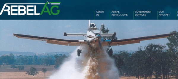
in a Dromader crop duster aircraft .
Nice to see some people are thinking. I would like to know what property or lives were at risk on 24 Oct in that huge area of bush where the fire could have been left to burn itself out – as thousands of fires do all the time.
ABC News – NSW bushfires: pilot killed in fire-fighting crash, Defence apology over Lithgow fire
Narromine News – Safety fears flagged earlier over make of plane in death crash
Bushfires in WA remote areas do occasionally affect minesites, and this happened last night in the Pilbara.
Mining companies are required by H&S laws to take adequate bushfire measures, which is why they never result in more than a brief temporary disruption.
Great photo! Over California or Colorado? With the propensity for bush-fire in Australia one would think that a few of the by now ageing old work-horses – 747’s could be purchased for this purpose, especially now with the new Dreaminers and Airbuses coming into general service.
A pet issue of mine. If you build on a floodplain you pay an appropriate insurance premium for flood damage, but bushfire damage is covered by a general home insurance policy. In effect the rest of us pay twice over (in insurance premiums and taxes for fire fighting resources) for a lifestyle choice of a generally affluent group of people to live in or close to the bush.
Worse, the subsidy encourages people to not take appropriate preventive actions, such as cutting bush, and encourages more to live in the bush. Not too long ago, I was in a forested area south of Perth and there was house after house every 30 meters or so, all within a couple of meters of bush and trees. Every single one of them would go in a bushfire.
I understand the reason for the difference. You can determine flood risk by looking at a map, but bushfire risk can only be assessed on the ground and at least once a year.
The solution is to exclude bushfire coverage from home insurance, but that is a political non-starter.
Here is the Evergreen site Faq on their 747 tanker.
www.evergreenaviation.com/supertanker/faq.html
The reports on the Sydney bushfires are utterly devoid of information as to what extent the affected areas had been protected by cool weather fuel reduction burns. What fuel reduction targets were set? What was achieved – this year? Last year? In the last five years?
We can’t control the weather or possibly hope to prevent ignition. We can only control the level of fuel. Firestorms are a lethal form of fuel reduction NSW and Victoria must cease relying on.
There is a statewide archive of scheduled hazard reduction burns here –
many refer to villages & towns –
I saw one ref to Bilpin –
28/09/2013 to 30/09/2013 Hawkesbury Between 2445-2455 Bells Line of Road, Bilpin Private NSW National Parks & Wildlife Service, Rural Fire Service
there may be others relevant.
I saw two refs to Blue Mnts –
21/09/2013 to 21/09/2013 Blue Mountains Mount Hay Road, Leura Private Private, Rural Fire Service
and –
27/09/2013 to 27/09/2013 Blue Mountains Between Cliff & Glenraphael Drive, Katoomba Local Government Authority Local Government Authority, Rural Fire Service
But I only looked back to 19 Sept.
It would be fascinating to know what was actually done and if a statewide map of areas burnt in hazard reduction is collated. My guess is they will be pinpricks compared to areas burnt by wildfire.
Interesting example of how the media believes its own distortion of reality about bushfires.
www.news.com.au/technology/american-network-nbc-publishes-map-showing-the-whole-of-australia-is-on-fire-oops/story-e6frfrnr-1226746114107
The image is derived from the Landsat satellite and is accurate. The fires are real, but they are in unpopulated areas and nothing is done about them. The issue in the East, isn’t the bushfires per se, but the fact people live in the bush. If nobody lived in the bush, which is the case of most of WA, the fires could be allowed to burn.
Can carry 75,700 litres which depending on the density of the retardant could be anything from 150 to 75 tons.
The retardant is dumped under pressure so this spreads it evenly and help make the retardant more effective.
Some interesting comments on this aviation specialists site re the death of pilot on 24 Oct water bombing inland from Ulladulla.


in a Dromader crop duster aircraft .
Nice to see some people are thinking. I would like to know what property or lives were at risk on 24 Oct in that huge area of bush where the fire could have been left to burn itself out – as thousands of fires do all the time.
ABC News – NSW bushfires: pilot killed in fire-fighting crash, Defence apology over Lithgow fire
Narromine News – Safety fears flagged earlier over make of plane in death crash
Bushfires in WA remote areas do occasionally affect minesites, and this happened last night in the Pilbara.
www.perthnow.com.au/news/western-australia/fmg-workers-evacuated-after-lightning-strike-causes-bushfire/story-fnhocxo3-1226746867729
Mining companies are required by H&S laws to take adequate bushfire measures, which is why they never result in more than a brief temporary disruption.
I know it is OT – but had to pass on this marvelous FOI – out of left field – discovery by Michael Smith –
The likes – dislikes & foibles of Princess the Senator Bob Carr – was Australian Foreign Minister – Discovered by FOI