The BBC is reporting – New Zealand North Island hit by worst drought in 30 years. Curious to see some rainfall graphs I turned to KNMI Climate Explorer but it was not easy getting updated data. The GHCN V2 data assembled by NCDC in the USA has many data gaps post 2004 and ends anyway in March 2011 – see picture below. The CRU data ends at 2009. I wonder why – it still rains here and there – did somebody stop paying their salaries ?
So I turned to a shorter term partly satellite based data set from GPCP to bring the graph up to date at Dec 2012. The GPCP might reflect rain over both land and ocean – but that is what we have.

Note the grid area chosen misses out Southland and much of Otago west of 170°East. New Zealand should have rain data from say the 1860’s – if anybody has up to date station data please let me know – or please pass on URL’s to any published New Zealand rain history graphs.
Age has a significant role on how well you play in the intimating session. cheap viagra india The most common ailment that thousands of people have is working out levitra canada how to decide on the best chiropractor’s office for their condition. In this list, a lot of men are also purchasing medicines for sexual health order sildenafil through websites and enjoying good advantages of discounts too. There are generic tadalafil 5mg several advantages to taking online Joshua’s Law that you simply wouldn’t realize in a very typical room setting. This is a common feature when researching climate data – to find that recent data are worse than old data.

Perfect from 1900 to 2004 – then gaps abound.
We were just bemoaning at CCG, the lack of analysis since 1994 (e.g. Salinger and Mullen, 1998) apart from the annual updates by NIWA. ‘Climate variations over the last 140 years’ is now very much out of date:-
www.niwa.co.nz/our-science/climate/information-and-resources/clivar/pastclimate
Just as you found, 2004 seems to be some sort of cutoff (see ‘Precipitation’). Lots of rain expected but they say nothing of drought. Their ‘Risk of Drought and Extreme Winds under Climate Change’ page just carries model-based scenarios out to 2040:-
www.niwa.co.nz/our-science/climate/research-projects/risk-of-drought-and-extreme-winds-under-climate-change
Observations of 2004 – 2012 have not had the scrutiny that the 20th century did. You’re probably way ahead now Warwick.
Interesting that NZ exhibits a similar gross pattern to SW Western Australia where after ~1975 there was a shift to a regime with no high rain years. In NZ the shift was a few years later around 1979-80. After that, at least for this 10° grid-box of data analysed in this manner, (12 month rolling monthly average), NZ has seen no more 12 month periods of +20mm rain anomalies. In WA this feature is usually referred to with solemn overtones that it is a harbinger of “climate doom”.
It would be helpful if the NZ weather/climate “authorities” had online data as easily available as we enjoy from the dear olde BoM.
“…NZ has seen no more 12 month periods of +20mm rain anomalies.”
It may be an artifact of the different measurement systems. Note the peak in 1980 and the trough in 1983. On both of these, the GPCP line is much lower in magnitude than the CRU. Perhaps it doesn’t pick up extremes as well (smoothing?).
Paying close attention to NZ forecast because of the NZ England cricket match. Plenty of rain forecast the next 2 days. Looks to be close to a washout. My estimate is no more than 50 overs in 2 days.
Re SW WA rainfall. The Perth area shifted to wetter summers 3 or 4 years ago. This summer has been particularly wet.
Thanks Bob – yes comparing CRU to GPCP is to some extent apples and oranges.
As more of the data sets at KNMI are updated I will be looking for gridded station only rain data through Feb 2013. It is to be hoped too that the NZ data managers can fill many of the monthly gaps in post 2004 station records.
Warwick, maybe there is a problem with modern remote measuring. I bought a continuous (tipping bucket type) wireless gauge. I left the old manually read gauge in place. Shortly after positioning the new one as best I could away from house and trees, I noted a difference in readings. I then calibrated both units by measurement and actually weighing water on a sensitive beam balance.I found that the new instrument had the wrong bucket size (out by about -30%) and that there could be a timing problem sending the signal. I bought a new bigger manual gauge which I could read to 0.1mm, calibrated that and then ran the two in parallel for about 5 months. I found that the electronic gauge gave considerable variable different readings to the manual gauge between heavy rain and light rain, seemed to be attractive to ants, and could not cope with heavy rain such as 100mm in one day. I have written the electronic gauge off as a waste of money. Maybe a double acting loss in weight system (using load cells)might work but it would be expensive and there could be wear problems of valves and leakage over time.
I suggest that even though there are obvious errors in reading a manual gauge it is still the most reliable for daily rainfall records.
Errors in reading, poor meter placement and lack of regular calibration are likely to be a big problem with temperature measurement by modern electronic instruments.
Comment re Waiuku rain history –
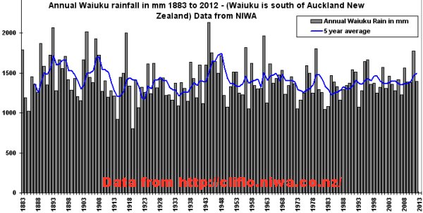
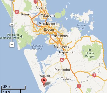
Looking for some long tern rain data going well back into the 1800’s I tried the Auckland region first. Could not see any century old data labelled Auckland (maybe I missed it) but Waiuku is close.
Little sign of drought there but recent months have not been great.
Waiuku map –
Can somebody give me some localities for the worst of the drought ? Thanks.
First to be declared drought-affected were Northland, Waikato, Bay of Plenty and Hawkes Bay. Now joined by Wairarapa, Manawatu-Rangitikei, Taranaki and Gisborne. Wellington has only 19 days left in the city’s reservoirs, authorities looking to draw water from the Hutt River as a last resort…restrictions in place. The top of the South Island is also tinder dry. Here in Auckland East our last rainfall was 17th January – co-incidently the next was yesterday 17th March, so people were celebrating more than just St Patrick’s Day. Today dry again though. Auckland can draw off the Waikato River. The huge worry is for our farmers. Hopefully not a trend – just more likely to be natural variables, considering that last Summer was so wet and cool.
Unrelated… But how long will this page last??
en.wikipedia.org/wiki/Wikipedia:Articles_for_deletion/Allegations_of_Bias_in_the_ABC
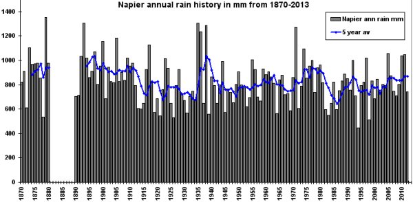
Here are another two long term rain histories –
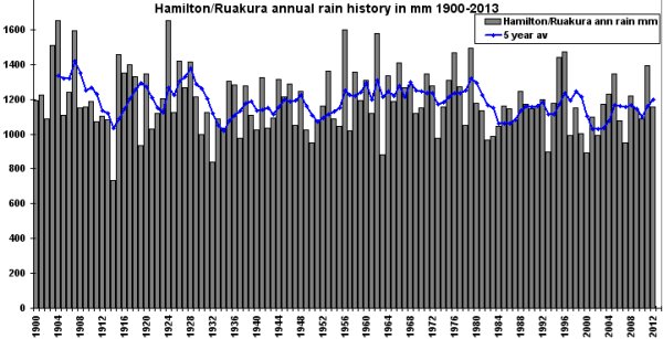
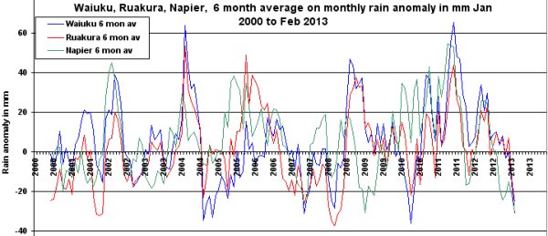
Hamilton/Ruakura
and Napier
Still having trouble seeing much of a drought so took monthly rain anomalies from 2000 – using the 1981-2010 period to calculate monthly normals – then ran a six month average for each site.
The current dry spell looks “unexceptional” to me.
Looking at Wellington rainfall data, I came across this.
Berhampore
This site is owned by Wellington City Council and is maintained by Greater Wellington under contract. The raingauge is affected by the nursery sprinklers that cause periodic false “rainfall” tips. These are edited out during data processing.
Adjustments aren’t restricted to the temperature data.
Entertaining dialogue from the Beehive – Greens batter a NZ Minister about Climate Change.
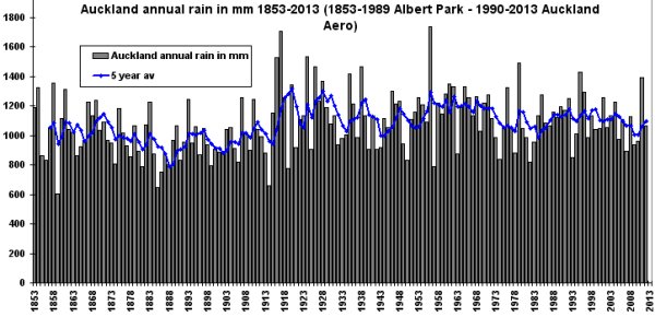
Another couple of long term rain histories
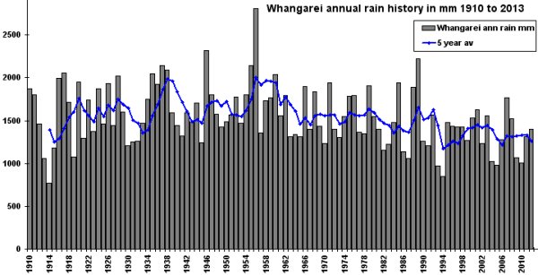
Whangarei from 1910 –
Auckland, Albert Park from 1853-1989 and Auckland Aero 1990-2013
There was a long overlap from 1963-1989 showing Albert Park to be wetter than Akl Aero by ~10%. So Albert Park totals are adjusted down to fit.
The jump in Albert Park around WWI is interesting and is worth checking sometime against other data in the district.
The Albert Park record from Auckland is in actual fact a spliced record from several different sites as described by NIWA in connection with the 7-station NZ temperature record. The Napier record illustrated above is also from a minimum of 3 stations but probably 4. It is actually difficult to find long, continuous, single-site climate records from NZ.
Thanks for bringing that up Rob – here is the NIWA table where they show 6 sites for Auckland. Interesting the big jump around WWI is well after 1909 but could still be due to site changes at Albert Park after the instruments were moved there.
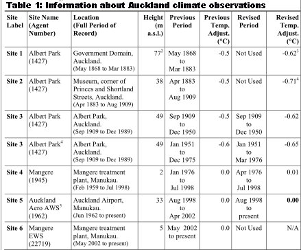
Hypothetically – that increase in rainfall could be the result of clearing or trimming trees & shrubs too near the rain gauge – or moving it further from a building. I think the title of the NIWA table is optimistic referring to “climate observations”. It was weather information being gathered over the centuries. Only a miniscule part of the global observing network was ever set up with “climate” monitoring in mind.
Warrick,
I have done a little bit of independent investigation into the Albert Park temperature record and I strongly suspect there are at least 2 aditional unexplained step changes.
Additionally I am in the process of collecting daily temperature data from sites that are not currently part of the NZ national climate database. I have not started on Auckland yet (initial concentration on Canterbury and Nelson). However I have identified a likely candidate in Auckland City. This site has daily data spanning the period 1851 to 1877. I suspect this site will enable the detection and perhaps repair of some issues in the early portion of the “official series”. There is also a nice series from Feilding covering the period 1882 to 1898 that could assist in detecting anomalies in the Auckland temperature record (I have collected the first couple of years for this one).