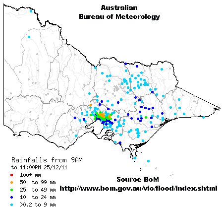
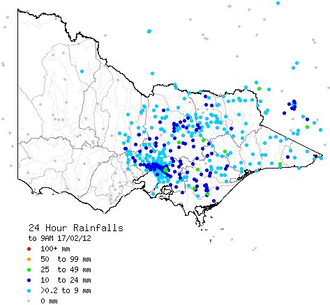
On the evening of Christmas Day a band of what the BoM called “super cell storms” swept through the Melbourne region from west to east. ABC Online story Wild storms lash Melbourne
I thought the neatly contoured pattern of rain that emerged after the event points to the possibility that in this event – the Melbourne urban heat island (UHI) might have attracted rain.

Certainly the ranges to the east and north-east of Melbourne did not attract rain from these storm cells like the centre of the urban area did.
This radar image from 6pm is typical, showing the storms erupting in a band – constantly forming and dying.
There is nothing new about the idea of UHI affecting rain – just search – uhi attracts rain – and there is much to read. I remember seeing case histories from Texas over the years. But on a longer term the signals from events a few hours in duration get obscured by other rain patterns.
Warwick,
Somewhat off topic but I know this has been an issue with you in the past. The WA Water Corporation website shows a dramatic drop off in water inflow to WA dams from about 1975. For example this year has seen on 80GL despite above average rainfall at the dams compared to 200-300 GL in pre 1975 times. It would appear to me that a fundamental change in stream management happened about 1975. Is this, to your knowledge, linked with any legislative change that restricted clearing etc? A search of govenment legislation records doesn’t show anything apart from a now superseded 1965 WA southwest waters management act which I can’t access.
Gidday Greg: Perth water issues are never off-topic here. Your suspicions are correct. This 2002 article from The West Australian sets the essentials out.
See my “There never was a rain shortage to justify seawater desalination for Perth’s water supply”
Many articles on Perth water issues in my blog “Water” Category – click on link down left hand side.
Also an old site – Perth water users
Warwick.
I have noticed a similar pattern in relation to Sydney. It always seems to rain more in and around Sydney than it does in parts outside the Sydney Basin. My conjecture (if rainfall stats could be shown to confirm my anecdotal observation) is that with all of the fuel consumption the extra moisture produced increases humidity, which then exaggerates any natural rain activity.
eg Methane: CH4 + 2O2 gives CO2 + 2H2O
That’s a lot of added moisture when you take into account all the carbon based fuels that are being burned in the area.
Urban aerosols are IMO a more likely explanation for this phenomena. Recent studies have found a large effect on precipitation intensity by aerosols.
The rainfall could well have been more intense had not it occurred over the Christmas break, due to the ‘weekend effect’.
ams.confex.com/ams/87ANNUAL/techprogram/paper_121013.htm
This event too lends a little support to what I said Boxing Day.

Is it pure chance that the net effect of multiple bands of rain sweeping through just happens to max through the peak UHI.